Technology to map and track underwater activities in the construction space has come a long way in the past 30 years—and the demand for advanced marine surveying capabilities has never been higher to maintain, adapt and expand marine infrastructure.
In recent years, there’s been a transformative shift in means and methods, driven by technological advancements that are redefining what is possible in the way of underwater visualization and mapping. With technology, what used to be the strict realm of hydrographic specialists—mapping seabeds, harbors and waterways—and operating in any dynamic condition, is now possible with a combination of global navigation satellite system (GNSS), inertial sensors and visualization software.
Beyond the quest for smaller more powerful solutions, a key focus in today’s environment is how to make marine surveying solutions intuitive, affordable, and available for as wide a variety of surveyors and construction users as possible. That quest not only expands capabilities to a broader swath of potential users, but is driving much needed productivity. Like many other construction related fields, marine construction and surveying face tremendous workforce shortages. There are only so many people who can go through the extensive education and experience required to become hydrographic experts in this field.
The challenge is to maximize the technology’s potential and drive greater efficiency in the industry—and that’s happening.
Building on Inertia
For many years, dredge and debris removal operations relied on manual means to manage underwater activities. In the case of dredging, tide gauges and paint marks around the dipper arm of the digger were the norm. For debris removal, there’s long been a heavy reliance on experience as well as divers, always a safety concern, to check progress. That changed considerably with the integration of GNSS and inertial technology with sensors such as multibeam sonar and associated visualization software.
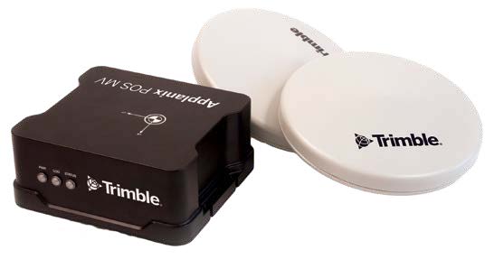
Trimble® Applanix’s Position and Orientation System for Marine Vehicles (POS MV) was the first such technology for marine applications back in the mid-’90s, effectively blending GNSS data with angular rate and acceleration data from an inertial measurement unit (IMU) and heading from the GNSS Azimuth Measurement System (GAMS) to produce a robust, accurate and time-stamped six degrees-of-freedom position and orientation solution. It was a solution uniquely suited to the requirements of precision marine motion sensing, hydrographic surveying and charting. Adding filtering tools for more accurate heave estimates, even in challenging survey conditions, further strengthened the surveying capabilities.
As the technology became more advanced and more accessible, these capabilities found their way onto more jobsites and became invaluable tools for a wider audience of marine construction workers.
Constellations of Opportunity
The inshore environment has long been an area where it is difficult to capture high-quality data, due to the numerous obstacles and interference sources, such as bridges, buildings and radio transmissions that disrupt GNSS signals and make it challenging to obtain the best possible results. More advanced technology is designed to address this challenge, providing robust solutions that can deliver accurate and reliable data even in these complex inshore environments where the need for precise surveying is the greatest.
Key to this challenge is making multiple GNSS constellations accessible within existing solutions. The ability to utilize multiple GNSS constellations including Galileo, GLONASS, BeiDou and QZSS as well as GPS, in a robust and reliable way in a marine environment is an important industry trend.
But it’s not just access to these constellations that’s driving change; it’s about how these multi-constellation GNSS-enabled solutions are integrated with other solutions and subsequently process the data to enable more reliable and accurate data.
In recent years, real-time correction services available via satellite or IP/cellular have also made a difference in the marine construction environment enabling centimetric position accuracy globally, even offshore where there are no nearby base stations. A real-time GNSS correction service leverages an absolute positioning technique to model and correct GNSS error sources, providing centimeter-level accuracy. Solutions such as Trimble CenterPoint® RTX have a horizontal root mean square error (RMS) accuracy of less than 2 cm and vertical RMS accuracy of less than 5 cm.
The technology has been tested by industry leading marine contractors to support positional accuracy, even offshore where there are no base stations for projects such as wind turbine installations.
Moving forward, there are continued advances to aided-inertial navigation, or the ability to use other sources of information to continuously correct or “aid” the INS errors. Trimble Applanix’s IN-Fusion+ is one such innovation. It relies on an advanced Kalman filter architecture that incorporates sophisticated inertial and aiding sensor error models developed using IMU compensation technology, as well as the latest in GNSS measurement processing and correction methodologies.
The latest generation IN-Fusion+ PP-RTX 2 & IN-Fusion PP-RTX service available in Applanix POSPac 9.1 (and later versions) supports better use of multi-frequency and multi-satellite constellations, including new signals from the Beidou-III generation, which contribute to improved robustness, reliability and reduced convergence time. IN-Fusion+ PP-RTX 2 also directly downloads the correction data without the need to upload trajectory information to the RTX-PP server. In addition, if an internet connection is not available, RTX corrections can be logged over the air from L-Band satellite using the Trimble GNSS-inertial hardware products, and processed directly in Applanix POSPac® software.
All of these advances have helped on a range of projects from dredging and underwater construction or deconstruction projects to engineering design and progress surveys at ports.
Harsh Realities
One port authority opted to use a combination of GNSS, IMUs and multibeam sonar to support the replacement of some lock gates. In this case, the challenge was to gather data in a challenging GNSS environment where satellites are masked and real-time kinematic (RTK) corrections are lost, directly affecting data quality.
In this case, the combination of the Applanix POS MV OceanMaster, equipped with the latest GNSS hardware and next generation IN-Fusion+ navigation algorithms, provided the port authority with an accurate mobile mapping and positioning solution. Making use of all available constellations and frequencies through Trimble ProPoint® technology further supported more observables, ensuring rapid reacquisition of RTK after an outage as well as adding robustness and accuracy to the real-time and post-processed solutions.
IN-Fusion+ Single Base tightly integrated all available GNSS constellations, frequencies and inertial data with an external static reference station in a forwards and backwards direction. The benefit of the increased observables reduced uncertainty around a bridge footing, for instance, from 10-20 cm to 5-10 cm, thus allowing for the creation of accurate seabed models and an improved engineering design.
Driving Underwater Efficiency
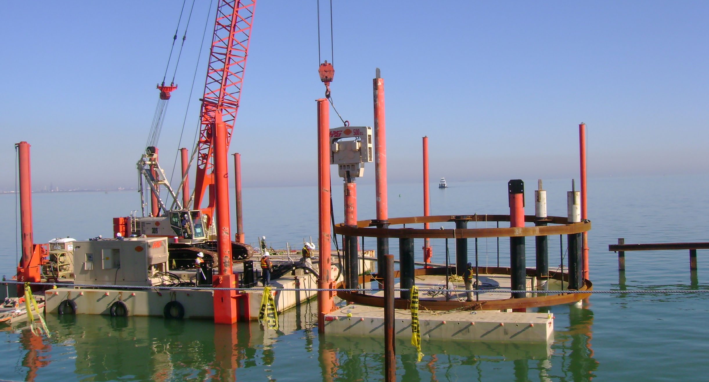
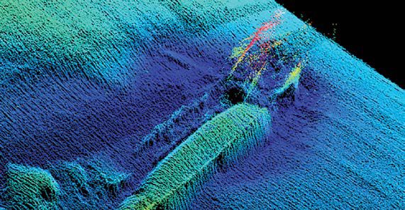
The deconstruction of the Tappan Zee bridge was the world’s first application of real-time machine guidance for on-water cranes/ excavators/ jack hammers with sonar verification. In this case, Tappan Zee Constructors combined real-time positioning, machine guidance and real-time visualization capabilities with sonar capabilities to drive safer, faster, more accurate dredging and demolition. Trimble Marine Construction Software (TMC), Trimble precision GNSS receivers and Teledyne SeaBat T20 high-resolution multibeam echosounder were used for subsurface applications
For instance, the combination of sensors was used on heavy equipment including excavators, clamshell cranes, cutter head on a dredge and more to provide operator clarity and visibility to work. The operators had a “bird’s eye view” of the jobsite with visibility of elevation, location, depth, bucket position and real-time 3D view of debris.
In addition to quickly identifying and removing debris underwater, precise positioning from the software helped Tappan Zee Constructors break up difficult components and material underwater, without relying solely on divers.
Soon after, those same advantages were realized for dredging projects. Just recently Australian contractor McQuade Marine, was contracted to dredge in and around the tight confines of berthing pockets and pontoons within Sanctuary Cove—and all within a two-week timeframe to minimize disturbance to boat owners and nearby residents. The total material quantity that needed to be removed was approximately 5,550 cubic meters of mud-like material that included silt, sand and clay.
As part of the Sanctuary Cove project, McQuade utilized a long-reach excavator on a purpose-built barge for dredging. Material was moved to the contractor’s split-hull trailing suction hopper for transport to other parts of the marina. With a machine guidance system on the excavator combined with a marine software overlay, the operator had 3D visibility of the seabed profile.
Alexander Brink, systems expert with McQuade, said, “It’s considerably more efficient than blind digging, or even our old machine control/dredger coordination workflows. With our old system, we couldn’t overlay the updated bathymetry for the operator to target the high spots not within tolerance. Now, hydrographic surveys can be conducted and then seamlessly uploaded straight into TMC for the excavator and dredger to immediately start targeting any areas not within tolerance—thereby maximizing targetable material.”
Sunspots of Activity
Largely due to past solar cycles, GNSS solution providers also continue to find ways to adjust for solar activity. The current 11-year solar cycle, Solar Cycle 25, began in 2019 and is anticipated to peak between now and 2026. As the solar cycle peak draws closer, the likelihood, frequency and potentially, the severity of events will likely increase even in the mid-latitudes. In some cases, positional accuracy degradation as a result of a solar disruption can reach as much as a meter. For those activities that require centimeter accuracy, that’s unacceptable.
Today’s receivers are much better equipped than in the past solar cycle thanks to technology advances. Ionospheric mitigation features have been added and improved upon in GNSS receivers over the past three solar cycles, with frequency independence just one such adjustment. Using more satellites across multiple independent satellite systems (e.g., GPS, GLONASS, Galileo, BeiDou) reduces the chance of errors from solar disturbances. It allows the receiver to de-weight or eliminate satellites that are severely affected by ionospheric disturbances or other error sources, and still have a significant number of satellites to use in the position solution, improving overall positioning accuracy.
As well, the software algorithms used in modern GNSS receivers are able to help mitigate the effects of ionospheric disturbances on satellite signals. They work by estimating parameters related to the ionospheric impact on each individual satellite signal and then adjusting the positioning calculation process to account for and compensate for the estimated noise/ errors introduced to each satellite’s measurements. This allows the receiver to still make partial use of satellites experiencing some ionospheric noise, rather than discarding them, improving overall positioning accuracy during disturbed conditions.

Trimble IonoGuard™️, for instance, is purpose-built to counteract the effects of Solar Cycle 25. This technology is designed to optimally process the GNSS measurements in the ProPoint position engine, while also improving signal tracking of disrupted GNSS signals. It has been shown to significantly improve positioning performance compared to older receiver software. It is an additional layer of protection that makes precise GNSS measurements possible under the most challenging atmospheric conditions, increasing the likelihood of uninterrupted and robust positioning data around the clock. During the May 10, 2024, solar storm event in Brazil, Peru and northern Sweden, the improvement in both horizontal and vertical positional accuracy using IonoGuard was significant. Intuitive Investments
Technology for underwater infrastructure work continues to advance with real-time sonar integration, which provides surveyors and contractors with stronger situational awareness of the underwater environment.
Along with ease of use, these advanced solutions are more accessible to contractors. Technologies that were previously considered cutting-edge, such as real-time sonar integration with machine guidance, are fast becoming mainstream in the industry — and costs are coming down.
In the past, marine surveying solutions could cost upwards of half a million dollars, but now there are options available for a fraction of that price. As the technology becomes more affordable and widespread, it opens the door for a wider range of users to adopt and leverage these advanced surveying capabilities, rather than being limited to only the most specialized and highly trained professionals.
The goal is to make the solutions intuitive and accessible, so users like crane operators or construction workers can leverage the capabilities without having to become experts in hydrographic surveying. Multibeam sonar technology, once the preserve of specialist hydrographic surveyors, is now available not just for mapping applications but also for real-time visualization and monitoring of progress, even in the most complex and challenging underwater projects.
Looking ahead, we’ll continue to see improvements in data precision, visualization capabilities, and ever tighter integration between positioning hardware and software, which will further improve productivity and jobsite safety.
Peter Stewart is the director of marine products at Trimble Applanix.