The Need for Vulnerability Assessment and Risk Reduction Strategies
The National Transportation Safety Board (NTSB) is providing the following information to urge owners of bridges over navigable waterways frequented by ocean-going vessels, the Federal Highway Administration (FHWA), the U.S. Coast Guard, and the U.S. Army Corps of Engineers to act on the safety recommendations in this report. We identified the need to safeguard bridges from vessel strikes as part of our ongoing investigation of the March 26, 2024, containership Dali’s collision with the Francis Scott Key Bridge, and the bridge’s subsequent collapse.
We completed a vulnerability assessment—a mathematical risk model calculated using data on bridge/span geometry and design, pier protection and lateral capacity, the characteristics of vessel traffic transiting the main navigation channel, waterway characteristics, and other factors—to determine how susceptible the Key Bridge was to collapse from a vessel collision and found that it was above the acceptable level of risk established by the American Association of State Highway and Transportation Officials (AASHTO) for such a collision.
We also identified 68 other bridges frequented by ocean-going vessels that were constructed before the AASHTO guidance was issued in 1991, have not undergone a vulnerability assessment based on recent vessel traffic, and, therefore, have an unknown level of risk of collapse from a vessel collision.
In this interim report, we urge the FHWA, Coast Guard, and Corps of Engineers to form a dedicated, interdisciplinary team that provides guidance and assistance to bridge owners on evaluating and reducing the risk of a bridge collapse from a vessel collision.
We also urge the owners of the 68 identified bridges to calculate whether the probability of a bridge collapse from a vessel collision is above the acceptable risk threshold established by AASHTO. If so, we urge them to develop and implement a risk reduction plan that includes input from the interdisciplinary team, identifies short- and long-term strategies to reduce risk, and considers the safety of the vessels and structures in the waterways.
Dali Collision with Francis Scott Key Bridge and Subsequent Bridge Collapse
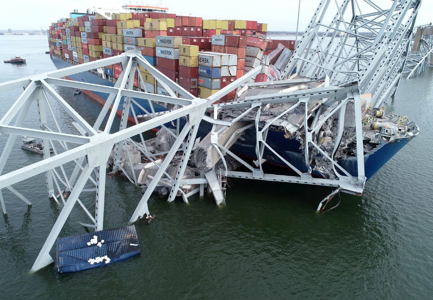
On March 26, 2024, about 0129 eastern daylight time, the 984-foot-long Singapore-flagged cargo vessel (containership) Dali was transiting out of Baltimore Harbor in Baltimore, Maryland, when it experienced a loss of electrical power and propulsion and struck Pier 17, the southern pier that supported the central span of the continuous through-truss of the Francis Scott Key Bridge. A portion of the bridge subsequently collapsed into the river, and portions of the pier, deck, and truss spans collapsed onto the vessel’s forward deck (see figure 1). A seven- person road maintenance crew and one inspector were on the bridge when the vessel struck it.
The inspector escaped unharmed, and one of the construction crewmembers survived the collapse with serious injuries. Six construction workers died as a result of the bridge collapse. One of the 23 persons aboard the Dali sustained a minor injury.
Francis Scott Key Bridge
The Key Bridge was located in Baltimore, Maryland, and carried Maryland 695 over the Patapsco River, from Baltimore to Dundalk, Maryland. The bridge was owned and operated by the Maryland Transportation Authority (MDTA) and opened to traffic on March 23, 1977. According to the MDTA, the overall length of the bridge was about 9,086 feet between the north and south abutments. The maximum vertical clearance for the Key Bridge above the main navigational channel, the 700-foot-wide Fort McHenry Federal Channel, was 185 feet.

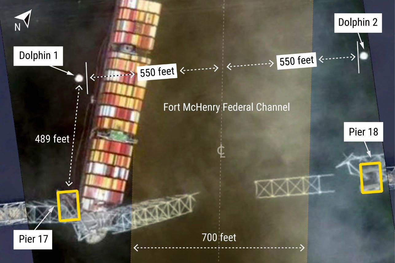
The Key Bridge was designed according to the 1969 edition of the AASHTO Standard Specifications for Highway Bridges (1970 and 1971 Interim Specifications). Although this guidance did not mention the risk of vessel collisions or a need for bridge protections, the Key Bridge was designed and built with physical protection systems to protect portions of the bridge exposed to possible damage by marine traffic. These protection systems (including four 28-foot-diameter dolphin structures, each with rubber fenders, and crushable concrete and timber fendering systems around Pier 17 and Pier 18) were in place when the bridge opened in 1977 (see figure 2). Dolphins are frequently used to protect bridge piers because they can slow, stop, or redirect an aberrant vessel.
The Key Bridge dolphins were constructed according to project- specific design criteria and, according to the MDTA, have retained these original specifications. The centers of Dolphin 1 and Dolphin 2 were located 489 feet west of the centers of Pier 17 and Pier 18, respectively (see figure 3).
In accordance with the National Bridge Inspection Standards, the Key Bridge and its pier protection systems were subject to regular safety inspections by nationally certified bridge inspectors. These periodic safety inspections, which included the dolphins for the Key Bridge, are intended to assess and document the physical and functional condition of a bridge and its components, and identify any changes from previously recorded conditions to ensure that any structural deficiencies posing an imminent threat to public safety are corrected. These inspections are “necessary to maintain safe bridge operation and prevent structural and functional failures.”
All dolphins were about 550 feet clear of the centerline of the Fort McHenry Federal Channel. None of the four dolphins were contacted by the Dali during the collision.
The Key Bridge’s most recent inspections in March 2021 and May 2023 found the condition of the deck, the superstructure, and the substructure as being in satisfactory condition, and the pier protection was rated as in place and functioning properly.
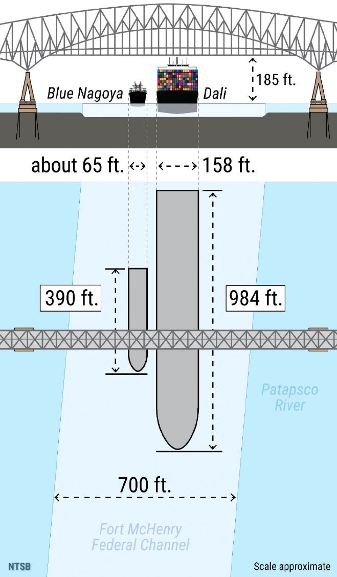
The Key Bridge’s pier protection was struck in 1980 when the 390-foot-long Japan-flagged containership Blue Nagoya, which had a displacement or weight about one-tenth that of the Dali, collided with Pier 17 following a loss of steering about 600 yards from the bridge; see figure 4 for a size comparison of the Blue Nagoya to the Dali. The vessel was stopped by the crushable concrete and timber fendering system at Pier 17, and the bow overhang contacted the pier’s A-frame. As a result of the collision, minor surface damage occurred on Pier 17’s columns and the pier’s fender was destroyed. The crushable concrete and timber fendering around the pier was reconstructed according to the original project-specific design criteria, and the minor damage to the columns was repaired.
Fort McHenry Federal Channel
The Fort McHenry Federal Channel, which runs within the Patapsco River along the length of the Port of Baltimore and under the Key Bridge, is a navigation channel maintained by the Corps of Engineers (see figure 5). The channel is 700 feet wide, 50 feet deep, and 4 miles long, with a vertical clearance of 185 feet under the Key Bridge. The main navigational channel near the bridge is straight, and there are no bends or turns.
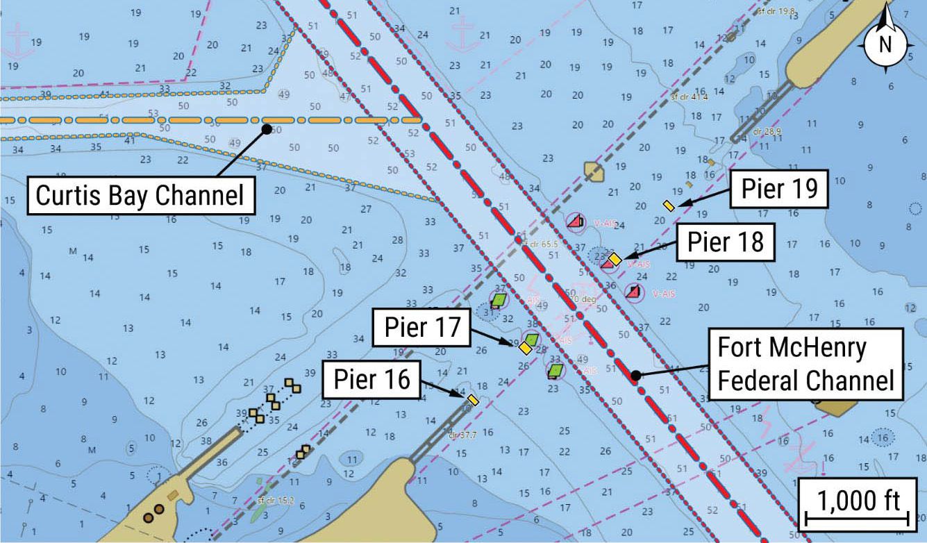
Ocean-going vessels passed under the bridge at the centerline of the Fort McHenry Federal Channel and were required to have a Maryland State Pilot aboard. In 2023, a total of 3,775 transits between Pier 17 and Pier 18 were recorded (1,902 inbound and 1,873 outbound).
Francis Scott Key Bridge Vulnerability Assessment Acceptable Threshold
Bridges built before 1991 were not required to undergo a vulnerability assessment; such an assessment had not been performed for the Key Bridge, which was constructed in 1977. Following the Dali collision, the NTSB conducted a vulnerability assessment of the bridge using the AASHTO Method II calculation to understand its level of risk at the time of its collapse. The calculated annual frequency of collaspe (AF) considered the factors listed above to assess whether this value was below AASHTO’s acceptable threshold value for a critical/ essential bridge’s probability of collapse. We calculated the AFs for both inbound and outbound vessel traffic for Piers 16, 17, 18, and 19, which are shown in table 1. These piers provided support to the portion of the bridge over the Fort McHenry Federal Channel. A comparison of the AFs of the piers in table 1 shows that a vessel collision with Pier 17 or Pier 18 was the largest contributor to the Key Bridge’s overall AF.
Since the Key Bridge’s opening in 1977, engineering and shipping advances—such as the 2016 Panama Canal expansion—have led to far larger vessels visiting, and increased vessel traffic volume to and from, the Port of Baltimore. Therefore, incorporating current vessel traffic parameters (and other environmental/waterway factors) into the AASHTO Method II vulnerability assessment calculation to evaluate the Key Bridge’s specifications, the NTSB determined that if the MDTA had calculated the AF for the Key Bridge before the collapse, it would have identified that the bridge’s risk level was almost 30 times greater than the AASHTO risk threshold for critical/essential bridges (0.0001). Therefore, the NTSB concludes that had the MDTA conducted a vulnerability assessment of the Francis Scott Key Bridge based on recent vessel traffic, as recommended by the 1991 and 2009 AASHTO Guide Specifications, the MDTA would have been aware that this critical/ essential bridge was above the AASHTO threshold of risk for catastrophic collapse from a vessel collision when the Dali collision occurred.
The 2009 AASHTO Guide Specifications are a resource for state Departments of Transportation (DOTs) and other bridge owners to better understand the overall safety of bridges within their inventory to “minimize their susceptibility to damage from vessel collisions.” For the Key Bridge, factors that contributed to this risk in the calculated vulnerability assessment included the piers adjacent to the main navigation channel and the channel size, which provided off-course vessels with little time for path correction before colliding with the bridge. Further, the locations and size of the dolphins did not fully protect Pier 17 and Pier 18 from a collision from an off-course vessel, and the speed and size (dimensions and weight) of modern vessels such as the Dali highlighted that the bridge piers were not strong enough to withstand a collision from a large ocean-going vessel.
Although some factors are challenging to modify for existing bridges, the process of calculating vulnerability assessments enables owners to make informed decisions to manage their assets, identify their bridges that may be susceptible to damage from a vessel collision, and appraise and prioritize vessel collision protection projects alongside other projects addressing highway asset needs and risks. When a bridge owner performs vulnerability assessments of structures in its inventory in accordance with the Method II calculation outlined by the 2009 AASHTO Guide Specifications, it is better equipped to understand the overall vulnerability of the bridges within its inventory. Therefore, the NTSB concludes that had the MDTA conducted a vulnerability assessment of the Key Bridge using AASHTO’s Method II vulnerability assessment calculation, the MDTA would have had information to proactively identify strategies to reduce the risk of a collapse and loss of lives associated with a vessel collision with the bridge.
FINDINGS
Had the Maryland Transportation Authority (MDTA) conducted a vulnerability assessment of the Francis Scott Key Bridge based on recent vessel traffic, as recommended by the 1991 and 2009 American Association of State Highway and Transportation Officials (AASHTO) Guide Specifications, the MDTA would have been aware that this critical/essential bridge was above the AASHTO threshold of risk for catastrophic collapse from a vessel collision when the Dali collision occurred.
Had the Maryland Transportation Authority (MDTA) conducted a vulnerability assessment of the Francis Scott Key Bridge using the AASHTO Method II vulnerability assessment calculation, the MDTA would have had information to proactively identify strategies to reduce the risk of a collapse and loss of lives associated with a vessel collision with the bridge.
The 30 owners of 68 bridges over navigable waterways frequented by ocean-going vessels are likely unaware of their bridges’ risk of catastrophic collapse from a vessel collision and the potential need to implement countermeasures to reduce the bridges’ vulnerability.