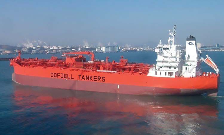
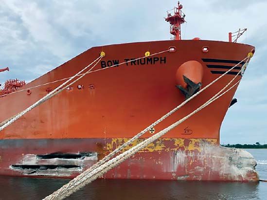
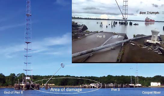
On September 5, 2022, about 1602 local time, the 600-foot-long tanker Bow Triumph was transiting outbound on the Cooper River near Naval Weapons Station, Joint Base Charleston, South Carolina, when the vessel struck Naval Weapons Station Pier B. The vessel’s bow sustained significant damage, and a 300-foot section of the pier collapsed. No pollution or injuries were reported. Damage to the vessel and pier was estimated at $29.5 million.
Background
Owned by Goldex Fortune Ltd. and operated by Odfjell Management AS, the Bow Triumph, built in 2015, was a 600-foot-long, Norway-flagged, steel-hulled, liquid bulk cargo vessel (tanker). The vessel was double-hulled, meaning its cargo tanks were within an inner watertight hull separated by ballast tanks or other spaces from its outer hull. Double-hull construction is intended to minimize the chances of cargo loss to the environment by providing protection from side or bottom damage. The tanker was outfitted with a single rudder and a fixed-pitch, right-handed turning propeller directly driven by a 14,521-hp, slow-speed diesel main engine.
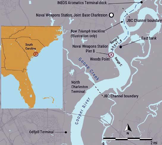
Pier B was 966 feet long and at a 30° angle to the west bank of the Cooper River. The pier consisted of a concrete deck supported by 20-inch concrete jacketed steel H-piles. The pier extended to the edge of the channel, which measured 600 feet wide at Pier B and quickly narrowed to 550 feet downriver.
Event Sequence
On September 5, 2022, after having finished discharging cargo at the INEOS Aromatics Terminal in Wando, South Carolina, the Bow Triumph prepared to depart. A Charleston Branch Pilots Association (CBPA) pilot came aboard the vessel at 1518, and the CBPA pilot and master conducted their exchange at 1520. During the exchange, the master informed the CBPA pilot that there were no deficiencies with the vessel’s propulsion, machinery, steering, or navigation systems. (A master/pilot exchange is required at the start of pilot transits and includes discussion of the vessel’s navigational equipment, any limitations of maneuverability, available engine speeds, berthing maneuvers, intended course and speed through the waterway, anticipated hazards along the route, weather conditions, composition of the bridge team and deck crew both forward and aft including bow lookout, and so on.)
About 1528, the Bow Triumph got underway on the Cooper River with the CBPA pilot, a docking pilot, and a crew of 24, en route to the Odfjell Terminal, 6.7 miles down the Cooper River, to discharge additional cargo. The docking pilot and the tugs Jeffrey McAllister and Capt. Jim McAllister assisted in the undocking, and then the docking pilot released the tugs. The vessel’s deepest draft was 27.6 feet at the stern.
About 1541, after the vessel was off the dock and turned around for the downriver transit, the CBPA pilot took the conn from the docking pilot. On the bridge were the CBPA pilot, the docking pilot, the master, the officer of the watch (the second officer), and a helmsman. Two crewmembers were standing by on the bow to let go the anchors, if needed.
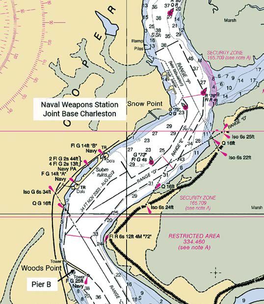
As they made their way down the Cooper River, the CBPA pilot conned the vessel through two bends: first, a port turn at 1547, shortly after entering the Joint Base Charleston Channel (referred to as the JBC Channel in US Army Corps of Engineers documents), and then a starboard turn at 1553 onto Range D (see figures 2 and 3). After passing through the second bend, the pilot continued using rudder commands to steer the ship toward the next bend, known as Shoal 4, a port turn onto the stretch of the river containing Range C.
(A range is a pair of stationary navigational markers used to indicate a safe passage for vessels navigating through a channel. The range may consist of two lights or markers (or both) that are separated in distance and elevation, so that when they are aligned, with one above the other, they provide a bearing (course) to steer the vessel safely through the waterway.)
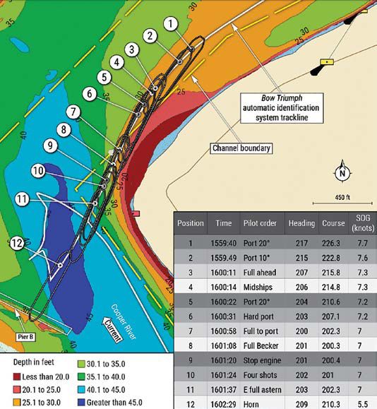
According to the CBPA pilot, as the Bow Triumph approached the bend, he maneuvered the vessel to the left side of the 650-foot-wide channel because he expected to slide toward the outside of the bend, as the estimated 1-knot flood current would push his vessel north when the bow entered the bend. The pilot reduced speed from full to half ahead at 1558:05, dropping the propeller rpm to allow for a “kick” from the engines for the turn. He ordered port 20° rudder at 1559:40 to begin the turn and to ensure “the rate of turn was significant and proper to make this turn.” He told investigators, “The ship responded immediately to my port 20.” He ordered port 10° rudder 9 seconds later.
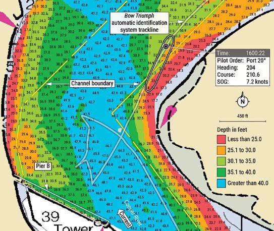
The pilot ordered full ahead at 1600:11, increasing the propeller rpm, and rudder midships at 1600:14. After ordering the rudder to port 20° at 1600:22, he noticed that the “rate of turn was not increasing” (see figure 4). The pilot ordered increased port rudder orders at 1600:31 and 1600:58, and then a full Becker rudder (the main rudder was at 45°, and the flap was at an angle of 90° to the ship’s centerline), at 1601:08.
Between 1600:22 and 1601:24, as the vessel drew nearer the left bend, its heading had only changed 2° to port and the vessel’s course over the ground showed an increase of about 10° to port as it drew closer to the left bank. At 1601:24, as the vessel was not turning as he expected it to, the pilot gave the order to drop anchor. Less than 1 minute later, at 1602:20, the Bow Triumph’s bow struck Pier B at a 90° angle (see figure 5).
(A Becker rudder, or flap rudder, consists of a movable rudder with a trailing edge flap activated by a mechanical linkage, producing a variable flap angle as a function of the rudder angle. Aboard the Bow Triumph, the main rudder could achieve 45°, and the flap could move another 45°, allowing a flap angle of 90° to the ship’s centerline.)
A 300-foot section of the pier collapsed after it was struck by the Bow Triumph. The pilot backed the Bow Triumph out from the debris with the assistance of the tugs Capt. Jim McAllister and Jefferey McAllister and ordered the anchor hauled in. (After undocking the Bow Triumph at the INEOS Aromatics Terminal, the tugs Capt. Jim McAllister and Jefferey McAllister had transited downriver ahead of the Bow Triumph to assist docking at the Odfjell Terminal.) At 1616, the pilot began conning the ship downriver without tug assistance. The vessel arrived at the Odfjell Terminal on the Cooper River at 1703.
Additional Information
The CBPA pilot, the Bow Triumph master, and other crewmembers on the bridge did not express any concerns as the ship was approaching the bend. The pilot, the Bow Triumph master, and bridge watchstanders told investigators that there was no issue with the vessel’s steering. Investigators reviewed voyage data recorder (VDR) data (audio and parametric) and found that the rudder matched orders given by the pilot up to the moment of the contact with the pier.
Damage
Damage to the Bow Triumph included a punctured bulbous bow and damage to side shell, frames, and stringers in way of the forepeak ballast tank and the no.1 starboard ballast tank, which compromised the watertight integrity of the hull (see figure 6). A September 7, 2022, diver survey report noted small areas on the keel, port of the centerline, where there was no marine growth and the hull plate coating (paint) was missing. The total cost of repairs was estimated at $2,459,570. The cost to demolish and reconstruct the damaged portion of Pier B was estimated at more than $27 million (see figure 7).
Bow Triumph Transit
The vessel’s passage plan for the transit calculated a tide of 5.9 feet (1.8 meters), the depth of water as 32 feet (9.7 meters), an underkeel clearance of 3 feet (0.9 meters), and a squat of 1.4 feet calculated at a speed of 6.7 knots.
(Underkeel clearance is the vertical distance between the bottom of a vessel and the seafloor or river bottom. Squat effect is a factor experienced in shallow water, generally when the waterway depth is less than twice the vessel’s draft, causing the ship’s bow or stern to trim lower [increasing the draft]. With a more restricted amount of water flowing beneath a ship, the water is forced under the bow at a higher velocity, creating lower pressure and decreased buoyancy. Squat is a function of ship speed over ground: the higher the speed the greater the squat effect.)
Automatic identification system (AIS) data from the pilot’s portable pilot unit (PPU), the Bow Triumph’s VDR, and the Coast Guard Navigation Center showed the pilot navigated the Bow Triumph within the channel boundaries shown on electronic charts until the bow first exited the channel at 1559:55, about 15 seconds after he started his turn and 2 minutes before the vessel contacted Pier B.
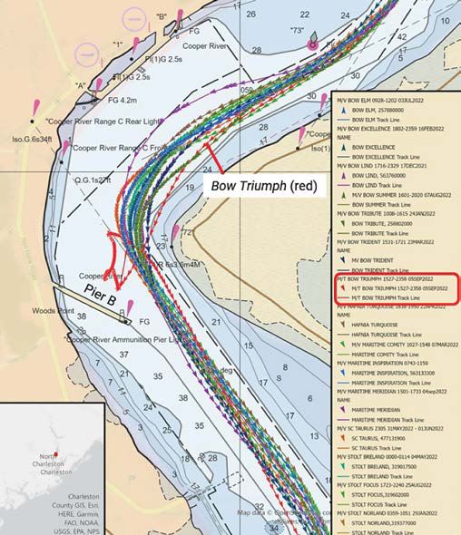
AIS data of the Bow Triumph and 14 other vessels of similar size and draft that departed from the INEOS Aromatics Terminal in the 12 months before the casualty show that the Bow Triumph pilot attempted to pass the closest to the bend (see figure 8).8 When asked about his trackline, the pilot told investigators that he did not intend to cut the corner. He envisioned a gradual turn through the bend with the flood tide pushing him toward the west bank as the bow entered Range C.
Postcasualty Actions
Following the casualty, while the Bow Triumph was docked at the Odfjell Terminal, Coast Guard personnel boarded the vessel and witnessed a test of the ship’s steering gear. They found the steering gear in working order.
The vessel’s classification society allowed the Bow Triumph to proceed directly to a shipyard in Florida for permanent repairs after temporary repairs were made in Charleston.
A day after the casualty, the Corps of Engineers conducted a multibeam depth survey of Shoal 4 and the bend. The CBPA reviewed the postcasualty soundings taken by the Corps of Engineers and then issued a reduction in maximum allowable drafts to transit through Range D based on the sounding data. As a result of a request by the CBPA, the Coast Guard placed a temporary buoy (72A) to mark the channel edge (and shoaling in the area) in Range D and announced the action in its weekly Notice to Mariners published on September 27, 2022. The Coast Guard removed temporary buoy 72A after the area was dredged in November 2022.
On January 17, 2024, at the request of the CBPA, the Coast Guard permanently established Cooper River lighted buoy 72A in the position where the temporary buoy had been (see Figure 9). The January 17, 2024, Notice to Mariners stated, “This additional aid to navigation will ensure commercial vessels can routinely transit this area in a safe manner.”
Personnel
The CBPA pilot began his apprenticeship with the CBPA in 1991, becoming a pilot in 1994. He estimated piloting 10,000–12,000 ships in his career, including 500 vessels on the Cooper River upriver of Goose Creek. This was his first trip on the Bow Triumph, but he had piloted vessels of the same class.
The Bow Triumph master held a certificate as a Master Mariner issued by the Republic of the Philippines. He had been a mariner for 26 years— the last 25 years of which were with the same employer—and he sailed as master the previous 3.5 years. He joined the vessel for the third time on March 25, 2022, to serve as master. This was his first time sailing in the port of Charleston.
Following the casualty, the CBPA pilot, docking pilot, master, second officer, helmsman, and the two crewmembers standing by the anchor submitted to alcohol and other drug testing in accordance with Coast Guard regulations, and the results were negative.
Waterway Information
The United States Coast Pilot states that the area that includes the JBC Channel “require[s] constant dredging to maintain them at or near project depths, due to the silting of [the] Cooper River.” Routine maintenance dredging for the channel was accomplished on a 15- to 20-month rotating cycle.
Limited commercial traffic used the JBC Channel. The INEOS Aromatics Terminal was the only facility upriver of Pier B that could berth vessels the size of the Bow Triumph. In the year before the casualty, only 15 vessels berthed at the INEOS Aromatics Terminal.
The project depth of the JBC Channel in the area of the bend was 35 feet, according to National Oceanic and Atmospheric Administration (NOAA) chart 11527 and the corresponding electronic chart. Because the JBC Channel is not a federal channel, depths shown on charts were not regularly updated and had not been updated since before 2011.
As stated in a 2019 dredging permit issued by the Corps of Engineers, Joint Base Charleston maintained the JBC Channel to provide sufficient depth for safe navigation and berthing of military vessels. The Corps of Engineers managed Joint Base Charleston’s maintenance dredging and material placement program by performing reimbursable work at Joint Base Charleston’s request. The dredging permit authorized the area of Shoal 4 to be dredged to a depth of 40 feet. The most recent dredging operations at Shoal 4 were completed on March 23, 2021, about 18 months before the casualty.
Data from the Corps of Engineers multibeam condition survey conducted a day after the casualty (September 6, 2022) showed that silting in the area of Shoal 4 had reduced the depth by more than 10 feet in portions of the JBC Channel since it was dredged in March 2021.
Dredging operations at Shoal 4 were later completed on November 14, 2022; the work had been scheduled under a maintenance dredging contract awarded before the casualty, on July 20, 2022.
The Coast Pilot states, “There is ship traffic to and from the Amoco Terminal (INEOS Aromatics Terminal) about 14 miles above the Battery, [and] ship movement is subject to certain restrictions by the Pilots’ Association.”10 To determine those restrictions in this area known for rapid shoaling, the CBPA used the depth at the INEOS Aromatics Terminal facility, taken by facility employees, where a vessel would dock; the Corps of Engineers depth data from surveys conducted for the JBC Channel; and information noted by pilots taking vessels to the INEOS Aromatics Terminal. On the casualty date, the vessel draft restriction imposed by the CBPA was 29.5 feet. Vessels calling on terminals farther upriver from the INEOS Aromatics Terminal were limited to a 25-foot draft.
The Corps of Engineers approved the Pier B installation in a bend of the Cooper River in 1953. Although no deep-draft commercial vessels were operating north of Pier B at the time of the permit approval, US Navy vessels did operate in the area upriver of Pier B, and the permit documents took into consideration that deep-draft commercial vessels would someday operate upriver of Pier B. On the date of the casualty, Pier B was no longer used for docking ships; it served as a recreational facility for Joint Base Charleston, where authorized personnel were allowed to fish.
Analysis
On September 5, 2022, about 1602 local time, while the tanker Bow Triumph was transiting the JBC Channel on the Cooper River, the vessel attempted to turn to port when navigating a bend in the river and struck a pier.
After making the right turn at 1553 onto Range D and transiting near the center of the channel, the Bow Triumph pilot began to favor the left side of the channel as the vessel approached the port turn (bend). The Bow Triumph bridge team and the pilot told investigators the rudder had responded as ordered by the pilot as the vessel approached the bend and that there was no issue with the vessel’s steering, and the VDR showed that rudder response matched the pilot’s orders.
When the pilot maneuvered the Bow Triumph closer to the left bank while approaching the turn, the vessel was susceptible to bank effect. Bank effect is experienced by ships maneuvering in confined waters (e.g., close to a canal bank, riverbank, or shoal). While making headway, water flow down the side of a ship creates positive pressure forward of the pivot point and negative pressure aft. In a channel, the resultant forces can attract a ship’s stern toward the bank (bank suction) and yaw the bow away from the bank (bank cushion). Though bank effect is often experienced in waterways with steeply sided banks, The Shiphandler’s Guide explains: “To a ship running in shallow water, with adjacent but gently shelving mud or sand banks, such as low-lying estuarial areas … the effect can be far more insidious and violent.”11 Generally, the faster the ship sails, the greater the suction at the stern. As it moved to the left side of the channel, the vessel traversed a section where shoaling had reduced the depth by more than 10 feet from the project depth. The Bow Triumph approached the turn running along the eastern (left) bank, and it had relatively open water to starboard. With the open water to starboard, there would not have been any opposing forces that offset the bank effect on the vessel’s port side. At the same time that the pilot was attempting to turn the vessel to port, the bank effect forces at the turn would have worked against the port turn by pushing the bow away (to starboard) and pulling the stern of the Bow Triumph toward the bank.
Additionally, as the bow of the Bow Triumph emerged from the shadow of the left bank, the roughly 1-knot current from the flood tide would have had an effect on the submerged portion of the vessel’s port bow— pushing it away from the bank and further working against the attempted port turn.
All the other vessels of similar size and draft departing the INEOS Aromatics Terminal in the previous 12 months approached the bend nearer the center of the channel than the Bow Triumph did on its casualty transit, and all were able to safely navigate the bend (see figure 8). Transiting in the center of the channel is prudent to avoid the risks associated with bank effect.
Analysis – Probable Cause
The National Transportation Safety Board determines that the probable cause of the contact of the Bow Triumph with Naval Weapons Station Pier B was the pilot’s decision to maneuver the vessel close to the left bank while approaching the turn immediately before the pier, exposing the tanker to bank effect, which the pilot’s subsequent rudder and engine orders could not overcome.
Lessons Learned – Planning for Hydrodynamic Forces in Areas Subject to Shoaling Hydrodynamic forces reduce rudder effectiveness (squat and shallow water effect) and yaw the bow away from the closest bank and pull the stern in (bank effect). Shoaling can reduce the water depth in shallow waters, such as channels, below charted or expected, and therefore exacerbate the forces on a vessel. Bank effect can have an undesired effect on vessels, even for the most experienced shiphandlers. Pilots, masters, and other vessel operators should consider the risks in areas known for shoaling when planning transits.