Marine Construction® Magazine

  • Home
  • RESOURCES
    • EQUIPMENT
    • MATERIALS
    • MANUALS
    • SERVICES
    • LEGAL
    • EDUCATION
    • SAFETY
  • SUBSCRIPTION
    • PREVIOUS ISSUES
  • SOFTWARE
  • ADVERTISING
  • WEBINAR
  • VIDEOS
  • CONTACT
  • BLOG
  • Classifieds
  • Jobs
MCMag NEWS
  • Link-Belt HTC-86100 Builds Cruise Terminal at Port Canaveral, Fla.   |   Jul 25 2022

  • Aarsleff’s Centrum Pile System does double duty on Dutch photovoltaic project   |   Jul 24 2022

  • Port of Los Angeles Enters Agreement with IBM to Create Cyber Resilience Center      |   Jul 17 2022

  • Greek temple ruins suggest cranes were in use as early as 700 B.C.   |   Jul 15 2022

  • Smith Brothers builds in Chesapeake Bay for more than 100 years   |   Jul 15 2022

  • Buried Wharves Uncovered on Manhattan Waterfront   |   Jul 15 2022

 
You are at :Home»NEWS»Buried Wharves Uncovered on Manhattan Waterfront
Egbert Viele’s Sanitary and Topological Map of the City and Island of New York, 1865, with the location of Burling Slip indicated with a star. Artificially made land is indicated in orange.

Buried Wharves Uncovered on Manhattan Waterfront

MCMag Jul 15 2022 NEWS Comments Off on Buried Wharves Uncovered on Manhattan Waterfront 65 Views

Slips (or docking basins) are the areas between wharves, which provide a place for ships to load and unload cargo. While digging to build the foundations of Imagination Playground in May 2009, archaeologists and construction workers uncovered the remains of two buried wharves.  

The first discovery, a 190-foot section of Codwise’s Wharf, was found along the eastern edge of John Street, which was built in stages between 1803 and 1807 by George Codwise Jr., a prominent New York merchant. The corner of a second wharf, Remsen’s Wharf, probably built about ten years earlier, was discovered near the corner of Burling Slip and Front Street.  

At the time of the first European contact, the East River shoreline in this area was located about one and a half blocks north of Front Street and the entirety of what is now Burling Slip was under water. The shoreline was characterized by an almost continuous network of wharves and slips, was built increasingly further out into the East River, responding to pressures for new commercial real estate and in order to address the poor conditions of the existing waterfront infrastructure. 

As the leading port in New York City, the South Street Seaport was an international center of commerce by the mid-nineteenth century. Burling Slip, like the shoreline that surrounded it, was filled and extended increasingly further into the East River in several construction episodes, the earliest of which occurred in the seventeenth century. 

While digging to build a playground, construction workers uncovered the remains of two buried wharves.

When the shoreline was extended around 1840, Burling Slip was filled in with loose sand, soil, and trash. Broken ceramics were also found, ranging from transfer-print plates to hand-painted cups and locally made stoneware. Some of these ceramics may have been part of a damaged shipment, thrown into the slip straight from the ship, while others may have represented locally generated refuse. 

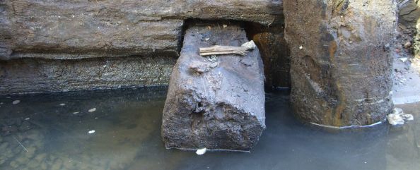
Wharves were built of hand-hewn squared pine and hemlock timbers from the Hudson Valley. The timbers were stacked horizontally, one on top of another, and notched together in a manner similar to how the walls of a log house are built. This technique was a typical way of building wharves in North America from the early 18th through the late 19th centuries. Codwise’s Wharf was somewhat unusual in that it was built in sections of linear bulkhead, instead of the more typical box-like crib form. Archaeologists believe that Codwise chose this technique because it allowed him to start construction before he had obtained permission to build on all of the necessary underwater lots.

2022-07-15
MCMag
Twitter Facebook linkedin Pinterest Email Print More

Authors

Posted by : MCMag
Previous Article :

Trimble showcases workflow technology in first MCMag Strategy Sessions webinar

Next Article :

Port of Los Angeles Enters Agreement with IBM to Create Cyber Resilience Center   

Related Articles

Greek temple ruins suggest cranes were in use as early as 700 B.C.

Greek temple ruins suggest cranes were in use as early as 700 B.C.

MCMag Jul 15 2022
Falling Overboard

Falling Overboard

MCMag May 23 2022
Denso Protal 600 Coal Tar Epoxy Coated Sheet Piles for Harris County, TX for Flood Control

Denso Protal 600 Coal Tar Epoxy Coated Sheet Piles for Harris County, TX for Flood Control

MCMag Dec 07 2021

Advertisement

Current Issue

Current Issue of Marine Construction Magazine Volume III 2022

Previous Issue

Marine Construction Magazine Vol II 2022

More Info!

Marine Construction Magazine Logo Marine Construction® Magazine publishes Six (6) Issues per year, once every 2-Months. We are by no means your typical publication. With over 30,000 readers, we pride ourselves on covering the topics of “actual usefulness” to our readers. Yes, we are a little unorthodox but…we like it like that. The bottom line is, if you are in the Marine Construction or related industry…you’ve come to the right place.

Random Posts

  • INNOVATIONS IN MARINE CONSTRUCTION

    INNOVATIONS IN MARINE CONSTRUCTION

    MCMag Nov 26 2019
  • Crane Safety Checklist

    Crane Safety Checklist

    MCMag May 23 2022
  • PERSONAL PROTECTION EQUIPMENT FOR WORKING OVER WATER

    PERSONAL PROTECTION EQUIPMENT FOR WORKING OVER WATER

    MCMag Jul 15 2020

Follow us

Sign up for our eNewsletter

© Copyright 2022, MarineConstruction®Magazine. All Rights Reserved